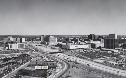
While recently Birmingham got the good news about winning a federal TIGER grant (which will allow, among other things, sidewalk and bike lane improvements around downtown), we also got the decidedly more challenging news that the downtown I-20/59 connector will be rebuilt by ALDOT pretty much in its current form–rather than sunken, or moved. Up in New Haven, CT another TIGER grant will allow the state and city to remove the Route 34 connector (above, ca. 1962) and replace it with landscaped streets, new mixed-use development, and bike access dubbed Downtown Crossing. New Haven and the state of Connecticut have been very deliberate in promoting the plan’s benefits to business growth, urban livability, and dispersal of car traffic along multiple city routes. It’s a big change in policy from the 1950’s, when that city was a national model for urban renewal and auto-influenced planning; this project alone displaced almost 1000 residents and hundreds of businesses in an effort to move cars more efficiently.
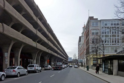
The connector effectively divided downtown: on one side lies the central business district and Yale University, on the other side Yale Medical School, the train station, and residential neighborhoods. In between became a no-man’s land of wide highway, parking lots, and garages, including the famous Temple Street Garage (Paul Rudolph, 1962, above) whose sinuous concrete curves have been much admired despite other, less positive attributes of this building. The urban impact of the garage, and the rest of the car-centric connector, can be seen in this photo where the historic fabric of New Haven faces a solid block of parking across a narrow street.
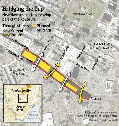
The map above shows the greater context, and how two cross streets will be reopened to traffic, extending the city grid (which by the way is also famous for being the first true urban grid in the US, ca. 1639). The center portion shown in yellow will be opened to private developers with an emphasis on the biotech industry.
Above is the rendering of one of the proposed new buildings. Despite the effort, there has been plenty of criticism of this plan, ranging from commuters anxious about how they will navigate the new streets, to citizens’ groups worried the plan is still too car-friendly, to local architects upset about the bland, “anywhere” quality of the proposed new architecture. Knitting the city back together across this wound while satisfying diverse constituencies is a real balancing act.
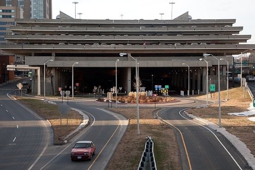
Another relic of the frenzy of automotive-related development from the heyday of this project is the Air Rights Garage (above), which perches over the connector and is slated to remain in the new plan. It will be fascinating to see how the development evolves. Kudos, overall, to New Haven and Connecticut at least trying to remedy old-fashioned ways of thinking about the city and its needs. Cars were–and are still–important. But they no longer should be considered the most important aspect of planning. Urban life is too complex for such simplistic thinking.
[thanks to new haven museum for the historic pic; payton chung for the Temple Street garage pic; Wall Street Journal for the graphic; New York Times for the rendering, and New Haven Independent for the Air Rights Garage pic]


Thanks for showing us up as everlastingly the cow’s tail in undoing past damage and avoiding present damage. I haven’t been quite as discouraged in a long time as I was when ALDOT blithely announced, in the face of all those plans and recommendations to the contrary, that it was merely going to resurface that miserable expressway through town. At least I think they got some objection to it, so maybe there’s a little hope.
It is my opinion that Birmingham will never be a thriving city at all until that expressway is out of there, either below grade or (better) moved to the north.
The other consolation for our own connector is that the City and stakeholders (Museum, BJCC, etc.) have been coordinating an effort to influence the replacement’s design, lighting, use of space underneath, etc. that would me a big improvement over what we have now. I imagine ALDOT is probably not on the same page as its counterpart in Connecticut, when it comes to progressive thinking about traffic! Thanks.
Just a random thought… if we absolutely have to live with the raised highway, it would be really cool if the space underneath could be converted to modern green space. Perhaps use strategic landscaping to help deaden the sound of the cars above (also assuming resurfacing helps in that regard). Keep it well lit at night. Use a huge concrete lemon to make some lemonade!
Yes! The City, BJCC, Art Museum, and others all agree with you and are working hard to make that happen. While not not on its surface ideal, the situation could just open up a very exciting opportunity to rethink the experience of “being under”. Thanks!
—–Original Message—–
Good report. I had read bits and pieces on this, so it helps to have the whole story (and maps). The extra cost of a dropped I -20/59 was used to kill it, but the long-term benefits not even measured. Hope BMA, BJCC and the city push for measures to temper the negatives (e.g. better sound buffering).
Thanks–yes, I still think an immense improvement can be made with sound buffers, column spacing, lighting/art, etc.
Responding to Philip: Extra cost is ALWAYS used to kill things (like the tunnel through Red Mountain, which was an issue starting in 1908!), and long-term benefits are NEVER considered. You know this, of course. Things aren’t much better in Washington these days, are they?
Ive said this before but how much easier it would be to move the through traffic to 11th avenue in a double deck and let the existing roadway ramp down to a boulevard for access to downtown. While there would be a few problems to solve, this would keep traffic moving while the other solutions require closure.
Cincy has also overcome very similar “obstacles” in dropping a roadway for the betterment of their downtown; http://www.cincinnati-transit.net/downtown_503x740.gif
RE pics above, NOT the picture one has in mind when thinking of New Haven and Yale! I was thinking, though, the other day as I drove past the BJCC on I-59, that what is important–critical, perhaps–in the redevelopment of the BJCC “cultural” district, including the new shops and hotel, is pushing the center of gravity, as it were, north. Certainly the interstate is a barrier of sorts that helps isolate the BJCC, but that’s not all that works against it. I doubt that there will EVER be an authentic and thriving “district” there if the BJCC remains a terminus along the north-south axis of downtown Birmingham. I say push into the hills and connect to Avondale and North Bham. Not to infringe on the limelight of Railroad Park, but a big open park running east from Oak Hill Cemetery would be really nice and help to connect with neighborhoods and future development. Bottom line: the BJCC should be a center core of activity that radiates in all directions, not just a coda on the backside of the city center….
Sorry, I meant to say Norwood, not Avondale….