Tag Archives: New York City

We’re back.

I’m excited to announce I’m reopening my design firm based in New York and Birmingham. Please look out for regular posts happening here in a few weeks, follow Erdreich Architecture on Instagram, and check out our updated website. Cheers everyone!
suburban transformation

A new chapter

Go west, young man

Go west, young man

In two days a new chapter starts: your author begins work with the New York design firm Sawyer/Berson. The commute to work will switch from a 15-second walk down Second Avenue North in Birmingham, to a roughly 35-minute walk and subway-ride on the BMT Broadway Line (the N, Q, R) from our apartment in Hell’s Kitchen on Manhattan’s West Side over to the East Side office near Gramercy Park. The morning view from the apartment is shown above, with the Hudson River and New Jersey visible to the right.

We will continue to be involved in downtown Birmingham through planned  projects like the Jefferson Loft Building, as well as management of the existing Phoenix Building and 2nd Row; this work will be based out of our new development office at the Frank Nelson Building on 20th Street North. As for this blog, I’m not quite sure what it will become. I may be able to keep writing about Birmingham with the aid of a few trustworthy volunteers who could help from the ground. Regardless, for many years, Birmingham and New York have easily been my two favorite cities in the US, and I look forward to new opportunities to help the former–and enjoy the latter!

Many thanks to all my readers for your support and comments. I sincerely hope that 2013 will bring great things to Birmingham and all of you. Cheers.

Can we afford it?

Angled parking, streetcars, and rising hemlines

Recent reports in the Birmingham Business Journal have quoted the new owner of the historic Empire Building (First Avenue North and 20th Street) as wanting to redevelop the building into “low-income housing” as opposed to the boutique hotel he’d originally suggested. The reason stated was financing would be easier to come by. Two things are clear: one, the Empire is one of the City’s most recognizable and important buildings, due to its membership in the “Heaviest Corner on Earth” collection of early skyscrapers which formed the nexus of downtown for decades (seen above, first tall building on the left, in a photo ca. 1918). Two, this City has a huge need for more quality affordable housing. Does it necessarily follow that this project makes sense?

Disappearing act: first storefronts, then adjacent businesses

Affordable housing projects downtown have had mixed success. Older developments such as the conversion of the historic Bankhead Hotel into a Section 8 housing development for seniors (above, Fifth Avenue North between 23rd and 24th Streets) often have reputations for poor management, loitering and shady deal-making by the entrances, and reducing demand for adjacent development. On the other hand, the Phoenix Building–which we developed some 7 years ago with a mix of moderate-income and market-rate apartments–has provided affordable loft spaces for artists and others who want to live in an artistic environment. It’s known for photography studios, art shows/performances, and an eclectic vibe. Downtown could use more living units like that. Producing this means choosing the right financing program, marketing astutely, and managing effectively. The developer must have a clear intent at the outset: is it just to fill up a building with lower-income pesople? Or is it part of a greater vision for integration with the surroundings, and for harnessing a meaningful vibe? At Empire, the developer’s true intent remains a mystery.

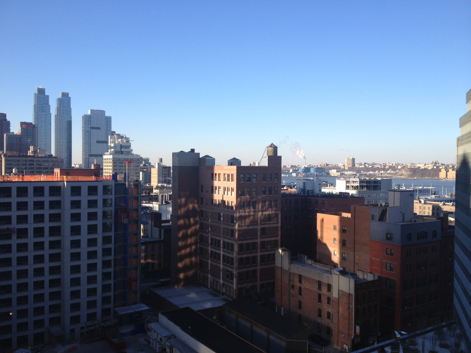
Hell’s Kitchen, meet Midtown West

As urban areas redevelop, existing, poorer populations are often replaced by newer, wealthier ones in a process known as gentrificationThe Empire report strikes many as out of sync with the normal trajectory: low-income users will be injected into an already gentrifying neighborhood. In New York City, an example of the more familiar trajectory is seen above across the street from our apartment building where poorer residents on fixed incomes share the block with young professionals moving in (Harborview Section 8 housing ca. 1976 to the left, with our building ca. 2012 in the background, West 55th Street looking south between 10th and 11th Avenues). New York has a long history of affordable housing intertwined with market-rate housing in a variety of ways. Other cities in the US–at least in post-war period–not so much. Affordable housing needs to be integrated into any vibrant urban neighborhood–but all-to-often, it isn’t. With negative consequences for all.

Save it, but in the right way

Another out-of-town investor has recently explored turning the Thomas Jefferson Hotel (above, 17th Street North between First and Second Avenues) into low-income housing. This building, with its prominence on the skyline, and interior filled with high-ceilinged, ornate ballroom and restaurant space, is much better suited to a sensitive mixed-use plan (which may include restaurant, event space, housing, and hotel rooms) currently being explored by the local Thomas Jefferson Tower group. We need more investment from places outside of Birmingham. But in this case, the local group is much better attuned to how this building could integrate into the neighborhood.

In the end, we want to encourage all incomes groups to live downtown. But the appropriate way to situate the mix is complex, and needs to be thoughtfully planned. We’d love another Phoenix Building. But not another Bankhead Tower.

[thanks to Birmingham Public Library for the Heaviest Corner pic; bamaboy for the Bankhead Hotel pic; caedan for the TJ Hotel pic]

Tale of two cities

Rather a different scale

New York City and Birmingham do not, for many if not most people, share much in common. One is bursting at the seams with new arrivals and fantastic mass transit; the other struggles with slow growth and not much transit at all. But these two cities happen to be your author’s favorites in the US–and a new opportunity has arisen to take advantage of both (a little corner of a new residential development, above at 54th Street and 10th Avenue on Manhattan‘s west side, will be the new pied-a-terre). We will be looking for ways to enjoin projects and resources in the Big Apple with those we continue to work on in the ‘Ham. We will also be racking up some frequent flyer miles.

It can all fit, I promise

In the meantime, the hunt for apartments in that famously space-poor city makes the recent New York Times article about micro-units all the more relevant. The image above illustrates that City’s effort to revise the local building code–which currently stipulates a minimum of 450 SF for a studio–to allow micro-units of less than 300 SF (full disclosure: your author lived in a 3rd floor walk-up apartment in the East Village which measured a whopping 340 SF). A competition is now underway for designers to produce creative visions for a model micro-unit apartment building, which could then set the stage for more plentiful (and hopefully more affordable) housing in New York.

So, stay tuned for more regarding the new Birmingham-New York City axis. It’s bound to be exciting.

[images courtesy The New York Times]

Questioning density

Did they get it right?

This blog tends to applaud urban density, deeming it essential to healthy, sustainable neighborhoods. Density is often defined by the amount of people occupying a square mile (or acre, or hectare). But what is the ideal level of density? How can that be objective rather than subjective? Is there a tipping point where you can have too much density? (Above is infill mixed-use construction at the corner of U Street and 13th Street in Washington, DC, a city with roughly 9500 people per square mile. Compare that to the City of Birmingham’s roughly 1500 people per square mile.)

We intuitively know that below certain levels of density, it’s hard to have adequate transit systems, walk-able streets, successful commercial areas, adequate greenways and natural areas, wise conservation of resources, etc. A fascinating article written by Lloyd Alter over on treehugger attempts to objectively analyze urban density, and arrives at some interesting conclusions.

So is NYC the best we have?

One of the article’s illustrations is the above map (courtesy UNEP) that shows urban density along the horizonal axis, and transport costs along the vertical. Note that transport costs include private and public transportation. At first glance this graph shows that New York City has the highest US density of major cities, and the lowest transport costs–validating the theory that the denser you get, the cheaper the transportation costs. But looking closer, you notice that Los Angeles, while having higher transport costs (all that freeway driving and limited public transit) has a HIGHER density as a city than New York (which includes very-dense Manhattan but also less dense boroughs). Also, much less dense Australian cities like Perth or Sydney have considerably lower transport costs than New York. So, at least in the middle of the graph, density and transport costs don’t necessarily correlate. And neither do our assumptions about the sprawl of LA vs. the tidy density of NYC.

Maybe this is it

Alter decides after examining the evidence that Greenwich Village (above) or central Paris–with their low-to-medium height buildings and small blocks–represent the ideal densities which support good transit, street life, and a sense of community without tipping over into the need for hugely expensive (and energy-intensive) mega-towers, vast parking garages, etc. Paris was largely rebuilt in its current form by imperial fiat; Greenwich Village is a 19th-century layering of former tenements and townhouses. Neither is necessarily possible to “replicate” today. But the issues surrounding urban density in these models and elsewhere are worth pondering as we decide how the Birmingham of the future will look.

[thanks to ncindc for the U Street pic; UNEP for the graph;  frankeggen for the Greenwich Village pic]

Parking, meters, technology

Free parking for now

For some time the parking meter situation in Birmingham has been dysfunctional. First, rates have been among the lowest in the US for major cities, encouraging the use of on-street parking at the expense of half-empty, tax-payer-funded parking decks and lots. Second, the antiquated pole-mounted meters have been subject to recent vandalism, with the City losing large amounts of revenue (see the Weld article here). Third, the promised roll-out of new meters has taken quite some time, with loads of free parking still available a block east from us on 2nd Avenue North, for instance (seen above next to an art installation at Space One Eleven gallery).

New technology, better service

In many cities, a much more advanced technology has been used for some time to handle urban on-street parking. Electronic “pay and display” meters (such as the one above in New York City) typically cover 8 to 15 spaces rather than just one. Instead of digging for change, you’re able to swipe a credit card or tap an account from your cell phone. A screen gives you options for time amounts; a receipt is printed which you post in your windshield. They are wireless and are powered with solar panels; the City can seamlessly adjust rates, power them down on Sundays, and troubleshoot remotely. While considerably more expensive than the old-fashioned type, these advanced meters are both much more efficient, and less susceptible to vandalism.

End of an era, at least in other US cities

The New York Times has an interesting article on replacing the last of thousands of old-fashioned meters in Manhattan, with the rest of the boroughs to follow (meter graveyard shown above). Birmingham should weigh the cost/benefits of getting advanced meter technology–at least in certain districts–before spending a lot on older, inefficient meters that will still be prone to vandalism. It’s always a bit discouraging to visit other cities and see electronic route information on bus stops, well-designed way-finding systems, or well-designed street furniture that collectively say “we are looking to the future”. Seeing new parking technology like this here would be a step in the right direction.

[thanks to antydiluvian for the Muni-Meter pic, and the NYTimes for the graveyard pic]

UPDATE:

An eagle-eyed reader alerted me to the fact that Birmingham DOES INDEED have a pilot program already set up with sophisticated, solar-powered pay-and-display units on 20th Street between Linn Park and City Hall:

Coming soon across the City?

Accepting both coins and credit cards, the units (above) are in place with ancillary signage denoting parking spots. Way to go Birmingham–we hope this pilot proves successful and it can be rolled out. A closer view:

The 21st century arrives

Pulling them in

Epicurean and design delight

Headed back from a long trip abroad, we had a day to spend in New York. As lunchtime approached, on a gorgeous (and low humidity) day, we decided to try the famous Shake Shack in Madison Square Park (night shot above). This “50’s burger-shack-modern”-style structure was impressive. Its scale is small and nestles in a corner of the park; the roof and back wall are covered with vine-wrapped trellises to help blend in with surrounding foliage; the bold signage and cool menu graphics are fun without feeling trendy.   It was designed by the NYC firm SITE and opened 7 years ago.

Believe it or not, it was worth the wait

Above is a shot of the line (roughly 30 minutes) that we stood in; initially we were dubious,  but as friends realized where we were, they sent jealous messages assuring us we were in for a treat. Indeed we were–right-sized portions of fantastic, fresh food, perfectly suited to the setting.  Birmingham continues to strengthen its foodie culture, with local chefs receiving national awards regularly.  Perhaps the new Barons baseball park to be constructed downtown could showcase similar, creative food concepts rather than the predictable chains. If we construct a new neighborhood, let’s entice the best of local talent to help sate our appetites.

UPDATE: For an in-depth article on Shake Shack’s creator, Danny Meyer, see the article from yesterday’s New York Times Magazine.

[thanks to wallyg for the night pic]

Mapping the future

Just a stroll down Second Avenue

Like many American cities planned in the 19th century, central Birmingham is designed around a rectangular, regular grid system of wide streets and avenues. The most famous example of how an orthogonal grid shaped the future of a city is found in Manhattan, where John Randel presented his map of the island (at that point mainly covered with farms and cow paths) in 1811.

This map, audacious at the time for imagining a pastoral island completely gridded and developed, is the subject of a great article and multimedia piece in the Times.  The above engraving shows how the new streets cut across existing farmland and house lots, often leaving structures in a precarious structural state. New York being New York, these older houses were torn down quickly for new development to accommodate a rapidly growing city.

Happy 200th birthday, NYC grid!

[Pic courtesy New York Times]